


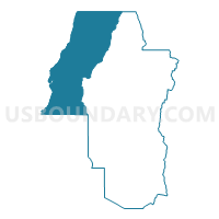
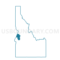
Voting District 003004, Adams County, Idaho
About
Outline

Summary
| Unique Area Identifier | 563674 |
| Name | Voting District 003004 |
| County | Adams County |
| State | Idaho |
| Area (square miles) | 333.34 |
| Land Area (square miles) | 330.37 |
| Water Area (square miles) | 2.97 |
| % of Land Area | 99.11 |
| % of Water Area | 0.89 |
| Latitude of the Internal Point | 45.06191000 |
| Longtitude of the Internal Point | -116.66846750 |
Maps

Graphs
Select a template below for downloading or customizing gragh for Voting District 003004, Adams County, Idaho


Neighbors
Neighoring Voting District (by Name) Neighboring Voting District on the Map
- Voting District 003003, Adams County, ID
- Voting District 003006, Adams County, ID
- Cambridge 8 Voting District, Washington County, ID
- Midvale 7 Voting District, Washington County, ID
- Pollock Voting District, Idaho County, ID
Top 10 Neighboring County Subdivision (by Population) Neighboring County Subdivision on the Map
- Council CCD, Adams County, ID (2,227)
- New Meadows CCD, Adams County, ID (1,749)
- Riggins CCD, Idaho County, ID (1,389)
- Halfway CCD, Baker County, OR (1,084)
- Cambridge CCD, Washington County, ID (935)
- Imnaha CCD, Wallowa County, OR (244)
Top 10 Neighboring Unified School District (by Population) Neighboring Unified School District on the Map
- Joseph School District 6, OR (2,129)
- Council School District 13, ID (2,025)
- Pine-Eagle School District 61, OR (1,681)
- Meadows Valley School District 11, ID (1,483)
- Salmon River School District 243, ID (1,459)
- Cambridge Joint School District 432, ID (1,147)
Top 10 Neighboring State Legislative District Lower Chamber (by Population) Neighboring State Legislative District Lower Chamber on the Map
- State House District 57, OR (57,718)
- State House District 60, OR (55,458)
- State House District 8, ID (38,711)
- State House District 9, ID (38,220)
Top 10 Neighboring State Legislative District Upper Chamber (by Population) Neighboring State Legislative District Upper Chamber on the Map
- State Senate District 29, OR (119,818)
- State Senate District 30, OR (115,913)
- State Senate District 8, ID (38,711)
- State Senate District 9, ID (38,220)
Top 10 Neighboring 111th Congressional District (by Population) Neighboring 111th Congressional District on the Map
Top 10 Neighboring Census Tract (by Population) Neighboring Census Tract on the Map
- Census Tract 9502, Adams County, ID (2,227)
- Census Tract 9601, Wallowa County, OR (1,957)
- Census Tract 9506, Baker County, OR (1,924)
- Census Tract 9501, Adams County, ID (1,749)
- Census Tract 9701, Washington County, ID (1,655)
- Census Tract 9604, Idaho County, ID (1,389)